|
|
Using the Track Feature |
To use the Track feature in MobiControl's Location Services, right-click on the device you wish to track, select Location Services, and click Track.
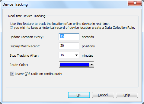
Device Tracking dialog box
The track feature will use the GPS unit associated with your mobile device to determine the current latitude and longitude of the device at a given schedule and send the co-ordinates back to the MobiControl Deployment Server. These co-ordinates are then displayed in the Location panel using Microsoft's Virtual Earth. The co-ordinates plotted in the Location panel represent the exact position of the device at the time of the request along with where the device has been since the request was initiated. To view where the device has been in the past, you need to use the show history option within MobiControl's Location Services.
In order to use the track feature, the device must be online and communicating with the MobiControlDeployment Server.
The following table describes each field in the dialog:
| Feature | Description |
|---|---|
| Update Location Every | Set a time interval in seconds (5–86400) for how frequently you would like to have the device location reported. |
| Display Most Recent | Choose a value to represent the number of recent positions (maximum 100) that you would like to see plotted on the map of the device(s) that you will be tracking. |
| Stop Tracking After | Set the time interval in minutes (5– 60) for when you would like to end tracking the device. |
| Route Color | Identifies the device route you will be tracking |
| Leave GPS radio on continuously | For faster response time from the GPS radio on the device, you should enable this check box. The device's GPS radio will constantly be on. |